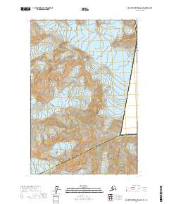
2017 Map of Mount Fairweather D-5 NW
USGS Topo · Published 2017About this map
Mt Fairweather dominates this high-altitude landscape along the rugged international boundary within Glacier Bay National Park. The topography is defined by massive ice fields and active glacial movement, with the Grand Plateau Glacier flowing through the northern reaches and the Sea Otter Glacier carving the central terrain. This 2017 study illustrates the complex convergence of administrative boundaries, where the Yakutat Borough Hoonah-Angoon Census Area line meets the international border between the United States and Canada. The sheer density of contour lines across the Fairweather Glacier reflects the extreme verticality of the Fairweather Range, providing an essential record of glacial extent and alpine geography in one of the most remote sections of the Alaskan panhandle.
Find a feature on this map
13 named features on this map. Tap any name to fly to it.
Don’t see what you’re looking for? This feature index may not catch every label — zoom into the map to look around manually.
Map Details
Editions of this 2017 Mount Fairweather D-5 NW Map
This is the sole edition of this map. No revisions or reprints were ever made.
Other maps of this area

1951 · Mt Fairweather
USGS Topo · 1:250,000

1952 · Skagway
USGS Topo · 1:250,000

1961 · Skagway A-7
USGS Topo · 1:63,360

1961 · Mount Fairweather D-6
USGS Topo · 1:63,360

1961 · Mount Fairweather D-5
USGS Topo · 1:63,360

1961 · Skagway A-8
USGS Topo · 1:63,360

1961 · Mt Fairweather
USGS Topo · 1:250,000

1961 · Skagway
USGS Topo · 1:250,000
2017 · Mount Fairweather D-6 NE
USGS Topo · 1:25,000
2017 · Mount Fairweather D-6 SE
USGS Topo · 1:25,000