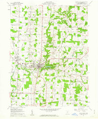
1961 Map of Mount Gilead
USGS Topo · Published 1962About this map
Mount Gilead serves as the focal point of this 1961 survey, situated at the confluence of several townships including Gilead, Congress, and Washington. The town's layout is defined by the New York Central tracks passing through nearby Edison and a robust network of rural routes like Marion Road and Iberia Road. The landscape is characterized by its numerous family burial grounds and community landmarks, such as River Cliff Cemetery, Armstrong Cem, and Montgomery Cem, which provide significant data for genealogical research.
Find a feature on this map
78 named features on this map. Tap any name to fly to it.
Don’t see what you’re looking for? This feature index may not catch every label — zoom into the map to look around manually.
Map Details
Editions of this 1961 Mount Gilead Map
3 editions found
Other maps of this area

1913 · Mount Gilead
USGS Topo · 1:62,500

1915 · Shauck
USGS Topo · 1:62,500

1915 · Marengo
USGS Topo · 1:62,500

1915 · Fredericktown
USGS Topo · 1:62,500

1916 · Mount Gilead
USGS Topo · 1:62,500

1943 · Shauck
USGS Topo · 1:62,500

1943 · Marengo
USGS Topo · 1:62,500

1943 · Mount Gilead
USGS Topo · 1:62,500

1943 · Fredericktown
USGS Topo · 1:62,500

1950 · Marion
USGS Topo · 1:250,000