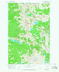
1965 Map of Mount Harding
USGS Topo · Published 1968About this map
McDonald Peak and West McDonald Peak tower over the high-altitude landscape of this 1960s Montana survey, where the McDonald Glacier feeds the headwaters of numerous mountain streams. The terrain is characterized by a dense concentration of glacial basins and alpine waters, including the expansive McDonald Lake and the smaller, high-elevation Summit Lake. The map delineates the Indian Reservation Boundary and the dividing line between Lake and Missoula counties, marking a wilder portion of the Flathead National Forest.
Find a feature on this map
35 named features on this map. Tap any name to fly to it.
Don’t see what you’re looking for? This feature index may not catch every label — zoom into the map to look around manually.
Map Details
Editions of this 1965 Mount Harding Map
2 editions found
Other maps of this area

1920 · Flathead Lake
USGS Topo · 1:125,000

1921 · Elbow Lake
USGS Topo · 1:125,000

1955 · Choteau
USGS Topo · 1:250,000

1956 · Wallace
USGS Topo · 1:250,000

1957 · Choteau
USGS Topo · 1:250,000

1958 · Choteau
USGS Topo · 1:250,000

1960 · Wallace
USGS Topo · 1:250,000

1962 · Choteau
USGS Topo · 1:250,000

1964 · Fort Connah
USGS Topo · 1:24,000

1964 · Ronan
USGS Topo · 1:24,000