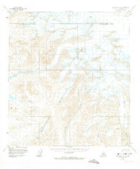
1951 Map of Mount Hayes B-6
USGS Topo · Published 1974About this map
Glacial ice and high-altitude drainage systems dominate this mid-century survey of the Matanuska-Susitna Borough. The landscape is defined by the massive Maclaren Glacier and the headwaters of the East Fork Susitna River, where numerous crevasses mark the slow movement of ice across the high mountains. Human activity is concentrated along the riverbanks, where sparse infrastructure like landing strips and scattered cabins provided essential outposts in this unforgiving environment. Evidence of early resource exploration is found at a lone mine near the Clearwater Fork. The map documents a network of primitive trails following the natural breaks of Cathedral Creek and Cottonwood Creek, reflecting a period when access to this interior region of Alaska relied almost entirely on light aircraft and seasonal ground routes.
Find a feature on this map
18 named features on this map. Tap any name to fly to it.
Don’t see what you’re looking for? This feature index may not catch every label — zoom into the map to look around manually.
Map Details
Editions of this 1951 Mount Hayes B-6 Map
2 editions found
Other maps of this area

1949 · Healy A-1
USGS Topo · 1:63,360

1949 · Mount Hayes A-5
USGS Topo · 1:63,360

1950 · Mount Hayes
USGS Topo · 1:250,000

1950 · Healy B-1
USGS Topo · 1:63,360

1950 · Mount Hayes A-6
USGS Topo · 1:63,360

1951 · Healy
USGS Topo · 1:250,000

1951 · Mount Hayes
USGS Topo · 1:250,000

1951 · Mount Hayes B-6
USGS Topo · 1:63,360

1951 · Healy C-1
USGS Topo · 1:63,360

1951 · Mount Hayes C-5
USGS Topo · 1:63,360