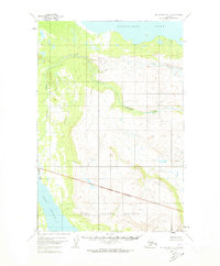
1951 Map of Mount Katmai D-5
USGS Topo · Published 1973About this map
Katmai National Monument encompasses the southern portion of this 1951 aerial photogrammetric survey, its approximate boundary cutting across a landscape dominated by the winding course of American Creek. This watercourse flows through a broad valley of wetlands and low relief, eventually feeding toward the southwest. In the northern reaches, the map captures the expansive shoreline of Nonvianuk Lake, while the southwest corner reveals a portion of Lake Coville. The topography is characterized by intricate contouring that illustrates the transition from the lake basins to the higher elevations within the monument. Mapped by the Geological Survey with control by the USCE, this sheet represents a period before modern infrastructure reached this part of Alaska, showing a wilderness area defined solely by its natural drainage patterns and the administrative lines of the Bureau of Land Management.
Find a feature on this map
6 named features on this map. Tap any name to fly to it.
Don’t see what you’re looking for? This feature index may not catch every label — zoom into the map to look around manually.
Map Details
Editions of this 1951 Mount Katmai D-5 Map
4 editions found
Other maps of this area

1948 · Mt Katmai
USGS Topo · 1:250,000

1951 · Mt Katmai
USGS Topo · 1:250,000

1951 · Mount Katmai C-6
USGS Topo · 1:63,360

1951 · Mount Katmai D-5
USGS Topo · 1:63,360

1951 · Mount Katmai C-5
USGS Topo · 1:63,360

1951 · Mount Katmai D-6
USGS Topo · 1:63,360

1951 · Iliamna A-7
USGS Topo · 1:63,360

1951 · Mount Katmai C-4
USGS Topo · 1:63,360

1951 · Mount Katmai D-4
USGS Topo · 1:63,360

1951 · Iliamna A-8
USGS Topo · 1:63,360