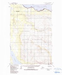
1951 Map of Mt. Katmai B-5
USGS Topo · Published 1991About this map
Nonvianuk Lake dominates the northern reaches of this Alaskan interior landscape, reflecting a time when federal land designations were being codified in the wake of the Alaska National Interest Lands Conservation Act. The terrain is defined by the hydrologic connection between major water bodies, specifically the route of American Creek as it flows toward the southwest corner near Lake Coville. The transition from the Katmai National Preserve in the north to the Katmai National Park and designated Katmai Wilderness to the south illustrates the complex layering of conservation boundaries in this era. This mapping, based on 1951 photography with minor revisions through the early 1980s, documents a landscape void of roads or permanent settlements, where the primary features are the raw topography and the legal lines drawn to protect it.
Find a feature on this map
9 named features on this map. Tap any name to fly to it.
Don’t see what you’re looking for? This feature index may not catch every label — zoom into the map to look around manually.
Map Details
Editions of this 1951 Mt. Katmai B-5 Map
4 editions found
Other maps of this area

1948 · Mt Katmai
USGS Topo · 1:250,000

1951 · Mt Katmai
USGS Topo · 1:250,000

1951 · Mount Katmai C-6
USGS Topo · 1:63,360

1951 · Mount Katmai D-5
USGS Topo · 1:63,360

1951 · Mount Katmai C-5
USGS Topo · 1:63,360

1951 · Mount Katmai D-6
USGS Topo · 1:63,360

1951 · Iliamna A-7
USGS Topo · 1:63,360

1951 · Mount Katmai C-4
USGS Topo · 1:63,360

1951 · Mount Katmai D-4
USGS Topo · 1:63,360

1951 · Iliamna A-8
USGS Topo · 1:63,360