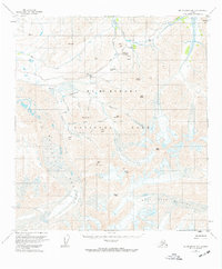
1954 Map of Mount McKinley B-1
USGS Topo · Published 1973About this map
McKinley National Park is defined by its massive ice fields and high-altitude crossings in this mid-century survey of the interior. The landscape is dominated by the sprawling Muldrow Glacier and Sunset Glacier, which carve through peaks like Mt Eielson and Scott Peak. Transportation through the interior is limited to the winding McKinley Park Road, which provides access to the Eielson Visitors Center and key vantage points such as Stony Hill Overlook. The terrain is characterized by high passes that connect remote drainage basins, including Thorofare Pass, Highway Pass, and Anderson Pass. The drainage network, featuring the Thorofare River and Moose Creek, illustrates the active glacial runoff that continues to shape the topography of the Alaska Range.
Find a feature on this map
38 named features on this map. Tap any name to fly to it.
Don’t see what you’re looking for? This feature index may not catch every label — zoom into the map to look around manually.
Map Details
Editions of this 1954 Mount McKinley B-1 Map
5 editions found

Other maps of this area

1949 · Healy A-6
USGS Topo · 1:63,360

1951 · Healy
USGS Topo · 1:250,000

1952 · Mount McKinley
USGS Topo · 1:250,000

1952 · Mount McKinley B-2
USGS Topo · 1:63,360

1952 · Mount McKinley B-1
USGS Topo · 1:63,360

1952 · Mount McKinley C-1
USGS Topo · 1:63,360

1952 · Mount McKinley C-2
USGS Topo · 1:63,360

1953 · Healy A-6
USGS Topo · 1:63,360

1954 · Healy C-6
USGS Topo · 1:63,360

1954 · Healy B-6
USGS Topo · 1:63,360