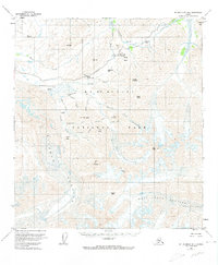
1954 Map of Mount McKinley B-1
USGS Topo · Published 1974About this map
The Eielson Visitors Center serves as a focal point within Mt McKinley National Park, situated where the Thorofare River and Gorge Creek meet. This mid-century survey illustrates the corridor of the Park Road as it winds through high-altitude terrain, passing landmarks such as the Stony Hill Overlook and crossing Highway Pass. The landscape is dominated by massive ice features, most notably the sprawling Muldrow Glacier, which flows past Green Point and Mt Eielson. To the south and east, the Sunset Glacier and West Fork Glacier carve through the peaks near Scott Peak and Sunset Peak. The map provides a detailed view of the drainage patterns from Moose Creek to the Thorofare River, documenting the intricate network of glacial runoff and mountain passes that defined travel in the park during the 1950s.
Find a feature on this map
40 named features on this map. Tap any name to fly to it.
Don’t see what you’re looking for? This feature index may not catch every label — zoom into the map to look around manually.
Map Details
Editions of this 1954 Mount McKinley B-1 Map
5 editions found

Other maps of this area

1949 · Healy A-6
USGS Topo · 1:63,360

1951 · Healy
USGS Topo · 1:250,000

1952 · Mount McKinley
USGS Topo · 1:250,000

1952 · Mount McKinley B-2
USGS Topo · 1:63,360

1952 · Mount McKinley B-1
USGS Topo · 1:63,360

1952 · Mount McKinley C-1
USGS Topo · 1:63,360

1952 · Mount McKinley C-2
USGS Topo · 1:63,360

1953 · Healy A-6
USGS Topo · 1:63,360

1954 · Healy C-6
USGS Topo · 1:63,360

1954 · Healy B-6
USGS Topo · 1:63,360