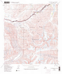
1954 Map of Mount McKinley B-1
USGS Topo · Published 1995About this map
Muldrow Glacier dominates the southwestern quadrant of this 1954 survey, showcasing the ice-carved topography of what is now Denali National Park. The Denali Park Road winds across the northern half of the map, reaching notable points of interest such as the Stony Hill Overlook and the Eielson Visitors Center. This area, deeply influenced by glacial activity, features several prominent ice fields including Sunset Glacier and West Fork Glacier, which feed into complex river systems like the Thorofare River. High-altitude passes such as Highway Pass and Anderson Pass provide critical crossing points through the high terrain surrounding Mount Eielson and Scott Peak. The map provides a detailed view of the backcountry landscape prior to later modern expansions, marked by the extensive Denali Wilderness boundary.
Find a feature on this map
42 named features on this map. Tap any name to fly to it.
Don’t see what you’re looking for? This feature index may not catch every label — zoom into the map to look around manually.
Map Details
Editions of this 1954 Mount McKinley B-1 Map
5 editions found

Other maps of this area

1949 · Healy A-6
USGS Topo · 1:63,360

1951 · Healy
USGS Topo · 1:250,000

1952 · Mount McKinley
USGS Topo · 1:250,000

1952 · Mount McKinley B-2
USGS Topo · 1:63,360

1952 · Mount McKinley B-1
USGS Topo · 1:63,360

1952 · Mount McKinley C-1
USGS Topo · 1:63,360

1952 · Mount McKinley C-2
USGS Topo · 1:63,360

1953 · Healy A-6
USGS Topo · 1:63,360

1954 · Healy C-6
USGS Topo · 1:63,360

1954 · Healy B-6
USGS Topo · 1:63,360