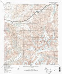
1954 Map of Mt. McKinley B-1
USGS Topo · Published 1995About this map
Muldrow Glacier dominates the western portion of this high-altitude landscape, a frozen river of ice that shapes the surrounding topography within Denali National Park. Based on surveys from the mid-1950s, the map highlights the infrastructure of the wilderness area, specifically the Denali Park Road as it winds through Thorofare Pass toward the Eielson Visitors Center. The intricate glacial drainage systems are clearly defined, showing the headwaters of the Thorofare River and numerous creeks such as Moose Creek and Stony Creek.
Find a feature on this map
38 named features on this map. Tap any name to fly to it.
Don’t see what you’re looking for? This feature index may not catch every label — zoom into the map to look around manually.
Map Details
Editions of this 1954 Mt. McKinley B-1 Map
5 editions found

Other maps of this area

1949 · Healy A-6
USGS Topo · 1:63,360

1951 · Healy
USGS Topo · 1:250,000

1952 · Mount McKinley
USGS Topo · 1:250,000

1952 · Mount McKinley B-2
USGS Topo · 1:63,360

1952 · Mount McKinley B-1
USGS Topo · 1:63,360

1952 · Mount McKinley C-1
USGS Topo · 1:63,360

1952 · Mount McKinley C-2
USGS Topo · 1:63,360

1953 · Healy A-6
USGS Topo · 1:63,360

1954 · Healy C-6
USGS Topo · 1:63,360

1954 · Healy B-6
USGS Topo · 1:63,360