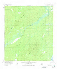
1958 Map of Mount McKinley D-6
USGS Topo · Published 1975About this map
The Kuskokwim River and its North Fork dominate this interior Alaskan landscape, which was documented through aerial photography and field annotation in the 1950s. This survey illustrates a vast network of water systems, including Fish Creek, Parker Creek, and the southern Lake Snohomish. The terrain is defined by the significant elevations of the Sischu Mountains and the Snohomish Hills, providing a clear record of the area's complex topography before modern development.
Find a feature on this map
11 named features on this map. Tap any name to fly to it.
Don’t see what you’re looking for? This feature index may not catch every label — zoom into the map to look around manually.
Map Details
Editions of this 1958 Mount McKinley D-6 Map
2 editions found

Other maps of this area

1948 · Kantishna River
USGS Topo · 1:250,000

1950 · Medfra
USGS Topo · 1:250,000

1951 · Kantishna River
USGS Topo · 1:250,000

1951 · Ruby
USGS Topo · 1:250,000

1952 · Mount McKinley
USGS Topo · 1:250,000

1952 · Ruby A-1
USGS Topo · 1:63,360

1952 · Kantishna River
USGS Topo · 1:250,000

1952 · Kantishna River A-5
USGS Topo · 1:63,360

1952 · Kantishna River A-6
USGS Topo · 1:63,360

1952 · Ruby
USGS Topo · 1:250,000