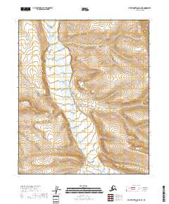
2018 Map of Mount Michelson B-5 NE
USGS Topo · Published 2018About this map
Kavik River dominates the western half of this 2018 topographic study, carving a braided path through the North Slope landscape. The river system's multiple channels suggest a dynamic hydrology typical of this Arctic region, where seasonal shifts reshape the gravel beds and watercourses. Smaller tributaries like Cobble Cr drain into the wider valley from the south, illustrating the drainage patterns that define the local terrain. The map is primarily organized by its Public Land Survey System divisions, including t1n r23e and t2n r22e, which provide the underlying grid for this undeveloped portion of the North Slope Borough.
Find a feature on this map
9 named features on this map. Tap any name to fly to it.
Don’t see what you’re looking for? This feature index may not catch every label — zoom into the map to look around manually.
Map Details
Editions of this 2018 Mount Michelson B-5 NE Map
This is the sole edition of this map. No revisions or reprints were ever made.
Other maps of this area

1951 · Mt. Michelson
USGS Topo · 1:250,000

1955 · Mount Michelson C-5
USGS Topo · 1:63,360

1955 · Mount Michelson C-4
USGS Topo · 1:63,360

1956 · Mt. Michelson
USGS Topo · 1:250,000
1971 · Mount Michelson B-5
USGS Topo · 1:63,360
1973 · Mount Michelson C-5
USGS Topo · 1:63,360

1978 · Mount Michelson C-4
USGS Topo · 1:63,360
1983 · Mount Michelson B-4
USGS Topo · 1:63,360
2018 · Mount Michelson B-5 SE
USGS Topo · 1:25,000
2018 · Mount Michelson C-5 SE
USGS Topo · 1:25,000