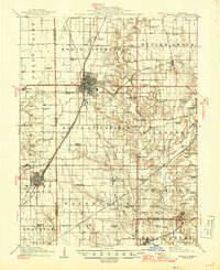
1915 Map of Mount Olive
USGS Topo · Published 1946About this map
The dense rail networks of central Illinois define this landscape, where the Litchfield hub serves as a critical junction for the Wabash and Illinois Central and the Chicago and North Western. This 1913 survey, updated for the mid-1940s, illustrates the peak of the region's agricultural and industrial infrastructure across the Macoupin and Montgomery County line. Small rural schoolhouses like West Point School and Hardenburg School are spaced across the township grids, reflecting the era's localized educational system.
Find a feature on this map
74 named features on this map. Tap any name to fly to it.
Don’t see what you’re looking for? This feature index may not catch every label — zoom into the map to look around manually.
Map Details
Editions of this 1915 Mount Olive Map
3 editions found
Other maps of this area

1912 · Gillespie
USGS Topo · 1:62,500

1915 · Gillespie
USGS Topo · 1:62,500

1915 · Mount Olive
USGS Topo · 1:62,500

1923 · Carlinville
USGS Topo · 1:48,000

1923 · Raymond
USGS Topo · 1:62,500

1925 · Carlinville
USGS Topo · 1:62,500

1925 · Raymond
USGS Topo · 1:62,500

1927 · Edwardsville
USGS Topo · 1:62,500

1931 · Carlinville
USGS Topo · 1:62,500

1932 · Edwardsville
USGS Topo · 1:62,500