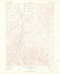
1961 Map of Mount Sopris
USGS Topo · Published 1963About this map
Mount Sopris dominates the southern landscape of this 1961 survey, its twin peaks rising sharply over the White River National Forest. The Crystal River valley serves as the primary corridor for human activity, where an Old Railroad Grade traces the river's western bank, marking the path of former industrial transport through the high country. Resource extraction is noted by a Gravel Pit near the river, while the complex hydrology of the region is detailed through numerous drainage systems like Thompson Creek and Prince Creek. Small-scale water management is evident at St John Res, and the high-altitude terrain is dotted with alpine features such as Thomas Lakes and Lewis Lake. This map captures a transition period in Pitkin County, documenting the shift from rail-dependent industry to the recreational and conservation-focused landscape of the mid-20th century.
Find a feature on this map
27 named features on this map. Tap any name to fly to it.
Don’t see what you’re looking for? This feature index may not catch every label — zoom into the map to look around manually.
Map Details
Editions of this 1961 Mount Sopris Map
5 editions found
Other maps of this area

1957 · Leadville
USGS Topo · 1:250,000

1959 · Leadville
USGS Topo · 1:250,000

1960 · Leadville
USGS Topo · 1:250,000

1960 · Capitol Peak
USGS Topo · 1:24,000

1960 · Redstone
USGS Topo · 1:24,000

1961 · Mount Sopris
USGS Topo · 1:24,000

1961 · Cattle Creek
USGS Topo · 1:24,000

1961 · Carbondale
USGS Topo · 1:24,000

1961 · Leon
USGS Topo · 1:24,000

1961 · Basalt
USGS Topo · 1:24,000