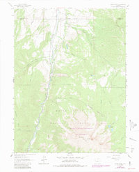
1961 Map of Mount Sopris
USGS Topo · Published 1984About this map
Mount Sopris and West Sopris dominate the southern half of this landscape, rising within the high alpine reaches of the White River National Forest. The valley floor is defined by the Crystal River, where an Old Railroad Grade follows the water's edge, marking a historic transportation corridor through the mountain pass. Industrial activity is noted by several Gravel Pits along the river banks, supporting local development in Pitkin County during the early 1960s.
Find a feature on this map
24 named features on this map. Tap any name to fly to it.
Don’t see what you’re looking for? This feature index may not catch every label — zoom into the map to look around manually.
Map Details
Editions of this 1961 Mount Sopris Map
5 editions found
Other maps of this area

1957 · Leadville
USGS Topo · 1:250,000

1959 · Leadville
USGS Topo · 1:250,000

1960 · Leadville
USGS Topo · 1:250,000

1960 · Capitol Peak
USGS Topo · 1:24,000

1960 · Redstone
USGS Topo · 1:24,000

1961 · Mount Sopris
USGS Topo · 1:24,000

1961 · Cattle Creek
USGS Topo · 1:24,000

1961 · Carbondale
USGS Topo · 1:24,000

1961 · Leon
USGS Topo · 1:24,000

1961 · Basalt
USGS Topo · 1:24,000