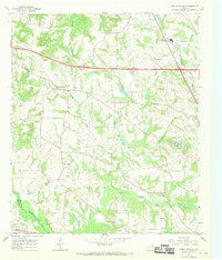
1966 Map of Mount Sylvan
USGS Topo · Published 1969About this map
Mount Sylvan and New Harmony anchor this mid-1960s landscape, illustrating the persistent rural settlement patterns of northwest Smith County. The terrain is defined by a dense network of tributaries including Caney Creek, Prairie Creek, and Chinquapin Creek, which feed toward the Neches River at the southwestern boundary. This era shows an active resource-extraction economy, with several Oil Wells and a Drill Hole scattered across the northern sections, alongside the Claypits near Thedford.
Find a feature on this map
39 named features on this map. Tap any name to fly to it.
Don’t see what you’re looking for? This feature index may not catch every label — zoom into the map to look around manually.
Map Details
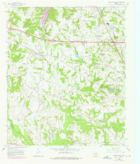
Editions of this 1966 Mount Sylvan Map
2 editions found
Other maps of this area

1948 · Tyler
USGS Topo · 1:62,500

1948 · Brownsboro
USGS Topo · 1:62,500

1949 · Tyler
USGS Topo · 1:62,500

1949 · Brownsboro
USGS Topo · 1:62,500

1956 · Tyler
USGS Topo · 1:250,000

1959 · Van Lake
USGS Topo · 1:24,000

1959 · Grand Saline
USGS Topo · 1:62,500

1960 · Lindale
USGS Topo · 1:24,000

1960 · Crow
USGS Topo · 1:24,000

1966 · Chandler
USGS Topo · 1:24,000