
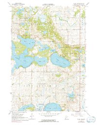
1967 Map of Mount Tom
USGS Topo · Published 1968About this map
Sibley State Park and its prominent landmark, Mount Tom, dominate this portion of Kandiyohi County. The landscape is defined by a dense network of glacial lakes and wetlands, including Norway Lake, Andrew Lake, and Lake Florida. This survey captures the rural infrastructure of the late 1960s, documenting local landmarks like the Swedish Ch and Lake Florida Ch, along with the Colfax Cem and Burbank Cem which serve the surrounding townships. Large sections of the terrain are dedicated to conservation, notably the National Wildlife Management Area, while numerous Gravel Pits indicate local industry. The map meticulously records fence and field lines, offering genealogists and land historians a clear view of mid-century property divisions and agricultural use across Colfax and Lake Andrew townships.
Find a feature on this map
28 named features on this map. Tap any name to fly to it.
Don’t see what you’re looking for? This feature index may not catch every label — zoom into the map to look around manually.
Map Details
Editions of this 1967 Mount Tom Map
2 editions found
Other maps of this area

1953 · Saint Cloud
USGS Topo · 1:250,000

1956 · Atwater
USGS Topo · 1:62,500

1957 · Saint Cloud
USGS Topo · 1:250,000

1958 · Saint Cloud
USGS Topo · 1:250,000

1958 · Pennock
USGS Topo · 1:24,000

1958 · Solomon Lake
USGS Topo · 1:24,000

1967 · Sunburg
USGS Topo · 1:24,000

1967 · Belgrade
USGS Topo · 1:24,000

1967 · Lake Johanna
USGS Topo · 1:24,000
1967 · Georgeville
USGS Topo · 1:24,000