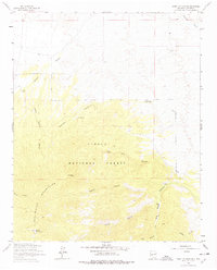
1964 Map of Mount Washington
USGS Topo · Published 1978About this map
San Mateo Mountains dominate this high-altitude landscape within the Cibola National Forest, where steep drainages and isolated peaks define the terrain. The presence of Monica Cabin and names like A-L Peak and A-L Spring suggest a history of high-country ranching and forest management during the mid-twentieth century. Water sources, vital in this arid environment, are specifically marked at Cooney Windmill and various springs. The map reveals a complex network of canyons, including Little Monica Canyon and Potato Canyon, that carve through the volcanic geology of the region. This survey, compiled from 1950s aerial photography and field-checked in the early 1960s, documents a period before significant modern development, focusing on the natural topography and the sparse human markers like the Jeep Trail that provided access to these remote New Mexico highlands.
Find a feature on this map
21 named features on this map. Tap any name to fly to it.
Don’t see what you’re looking for? This feature index may not catch every label — zoom into the map to look around manually.
Map Details
Editions of this 1964 Mount Washington Map
2 editions found
Other maps of this area

1888 · Bernalillo
USGS Topo · 1:125,000

1889 · Albuquerque
USGS Topo · 1:125,000

1892 · San Pedro
USGS Topo · 1:125,000

1893 · Albuquerque
USGS Topo · 1:125,000

1917 · Estancia
USGS Topo · 1:125,000

1934 · East Albuquerque
USGS Topo · 1:24,000

1938 · Albuquerque
USGS Topo · 1:62,500

1952 · Hubbell Spring
USGS Topo · 1:24,000

1952 · Los Lunas SE
USGS Topo · 1:24,000

1954 · Bosque Peak
USGS Topo · 1:24,000