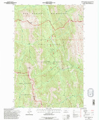
1995 Map of Mount Wright
USGS Topo · Published 1997About this map
The Sawtooth Range dominates this mid-1990s survey of the Rocky Mountain Front, where the sharp transition from plains to alpine peaks defines the landscape. The Lewis and Clark National Forest and the Bob Marshall Wilderness converge here, centered on prominent summits like Mount Wright and Mount Lockhart. The hydrography is particularly detailed, tracing the headwaters of the Teton River through the West Fork, Middle Fork, and East Fork. Human activity is concentrated around the Teton Pass Winter Sports Area, with its documented ski lift and parking facilities, providing a record of recreational infrastructure before modern expansions. Notable trails and watercourses like Waldron Creek and Jones Creek provide context for backcountry routes and drainage patterns used by foresters and hunters throughout the late twentieth century.
Find a feature on this map
30 named features on this map. Tap any name to fly to it.
Don’t see what you’re looking for? This feature index may not catch every label — zoom into the map to look around manually.
Map Details
Editions of this 1995 Mount Wright Map
This is the sole edition of this map. No revisions or reprints were ever made.
Other maps of this area

1903 · Saypo
USGS Topo · 1:125,000

1914 · Heart Butte
USGS Topo · 1:125,000

1918 · Heart Butte
USGS Topo · 1:125,000

1955 · Choteau
USGS Topo · 1:250,000

1957 · Choteau
USGS Topo · 1:250,000

1958 · Choteau
USGS Topo · 1:250,000

1958 · Ear Mountain
USGS Topo · 1:24,000

1958 · Cave Mountain
USGS Topo · 1:24,000

1958 · Porphyry Reef
USGS Topo · 1:24,000

1958 · Mount Wright
USGS Topo · 1:24,000