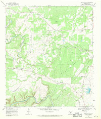
1968 Map of Mountain City
USGS Topo · Published 1971About this map
The Blanco River meanders across the southern edge of this Hill Country landscape, defining a region where cattle ranching and early aviation shaped the local economy. In the late 1960s, the area around Mountain City and Hay City remained dominated by sprawling family estates such as Kuykendall Ranch, Farris Ranch, and Michaelis Ranch. These holdings are interspersed with practical infrastructure including several gravel pits and a network of landing strips, such as the one serving the Rutherford Ranch.
Find a feature on this map
30 named features on this map. Tap any name to fly to it.
Don’t see what you’re looking for? This feature index may not catch every label — zoom into the map to look around manually.
Map Details
Editions of this 1968 Mountain City Map
4 editions found
Other maps of this area

1887 · Blanco
USGS Topo · 1:125,000

1894 · Blanco
USGS Topo · 1:125,000

1896 · Austin
USGS Topo · 1:125,000

1897 · Austin
USGS Topo · 1:125,000

1910 · Austin
USGS Topo · 1:125,000

1911 · San Marcos
USGS Topo · 1:125,000

1919 · San Marcos
USGS Topo · 1:125,000

1929 · Hunter
USGS Topo · 1:62,500

1953 · Seguin
USGS Topo · 1:250,000

1954 · Llano
USGS Topo · 1:250,000