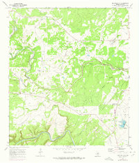
1968 Map of Mountain City
USGS Topo · Published 1974About this map
Mountain City and the northern edge of Kyle anchor this Central Texas landscape during a period of steady ranching and early rural transition. The terrain is defined by the winding course of Onion Creek and the Blanco River, which frame a territory of significant family ranch holdings. Notable agricultural sites such as the Kuykendall Ranch, Michaelis Ranch, and Farris Ranch illustrate the mid-20th-century land use patterns of Hays County.
Find a feature on this map
30 named features on this map. Tap any name to fly to it.
Don’t see what you’re looking for? This feature index may not catch every label — zoom into the map to look around manually.
Map Details
Editions of this 1968 Mountain City Map
4 editions found
Other maps of this area

1887 · Blanco
USGS Topo · 1:125,000

1894 · Blanco
USGS Topo · 1:125,000

1896 · Austin
USGS Topo · 1:125,000

1897 · Austin
USGS Topo · 1:125,000

1910 · Austin
USGS Topo · 1:125,000

1911 · San Marcos
USGS Topo · 1:125,000

1919 · San Marcos
USGS Topo · 1:125,000

1929 · Hunter
USGS Topo · 1:62,500

1953 · Seguin
USGS Topo · 1:250,000

1954 · Llano
USGS Topo · 1:250,000