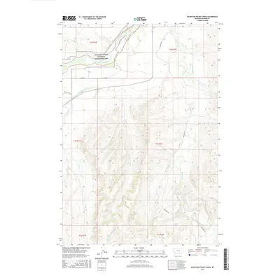
2017 Map of Mountain Pocket Creek
USGS Topo · Published 2017About this map
Bighorn Canyon National Recreation Area occupies the northwestern corner of this landscape, where the Bighorn River enters from the south. The terrain is defined by a dense network of seasonal drainages and sophisticated irrigation works that support this Big Horn County region. Water management is central to the area's geography, visible through the Big Horn Canal and various systems such as the Soap Cr Ditch and Krone Ditch. These man-made channels diverge from natural waterways like Soap Cr and Mountain Pocket Cr to feed the local agricultural parcels. Local transportation follows the contours of the land, with Soap Creek Rd and the Three Mile Roads providing access to the interior foothills and creek beds.
Find a feature on this map
21 named features on this map. Tap any name to fly to it.
Don’t see what you’re looking for? This feature index may not catch every label — zoom into the map to look around manually.
Map Details
Editions of this 2017 Mountain Pocket Creek Map
This is the sole edition of this map. No revisions or reprints were ever made.
Other maps of this area

1894 · St. Xavier
USGS Topo · 1:125,000

1901 · St. Xavier
USGS Topo · 1:125,000

1915 · Spenceville
USGS Topo · 1:31,680

1954 · Hardin
USGS Topo · 1:250,000

1957 · Hardin
USGS Topo · 1:250,000

1958 · Hardin
USGS Topo · 1:250,000

1960 · St Xavier
USGS Topo · 1:24,000

1960 · Mission Coulee
USGS Topo · 1:24,000

1964 · Peyote Point
USGS Topo · 1:24,000
1964 · Mountain Pocket Creek
USGS Topo · 1:24,000