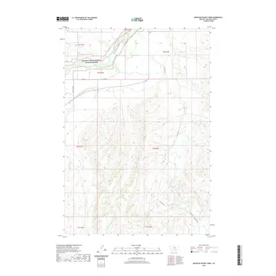
2020 Map of Mountain Pocket Creek
USGS Topo · Published 2020About this map
The Bighorn River cuts through the northern reaches of this landscape, flanked by the protected lands of the Bighorn Canyon National Recreation Area. This terrain is defined by a complex network of drainage and irrigation, essential for managing water in the Big Horn County environment. The Big Horn Canal and various irrigation features like the Soap Cr Ditch and Krone Ditch reflect the human effort to divert water from natural courses such as Soap Cr and Mountain Pocket Cr for agricultural use. Small roads like Soap Creek Rd and the Three Mile Roads provide limited access to the deeply folded topography of the southern sections. This 2020 record documents the modern intersection of public recreation space and the local water infrastructure required to sustain the surrounding region.
Find a feature on this map
20 named features on this map. Tap any name to fly to it.
Don’t see what you’re looking for? This feature index may not catch every label — zoom into the map to look around manually.
Map Details
Editions of this 2020 Mountain Pocket Creek Map
This is the sole edition of this map. No revisions or reprints were ever made.
Other maps of this area

1894 · St. Xavier
USGS Topo · 1:125,000

1901 · St. Xavier
USGS Topo · 1:125,000

1915 · Spenceville
USGS Topo · 1:31,680

1954 · Hardin
USGS Topo · 1:250,000

1957 · Hardin
USGS Topo · 1:250,000

1958 · Hardin
USGS Topo · 1:250,000

1960 · St Xavier
USGS Topo · 1:24,000

1960 · Mission Coulee
USGS Topo · 1:24,000

1964 · Peyote Point
USGS Topo · 1:24,000
1964 · Mountain Pocket Creek
USGS Topo · 1:24,000