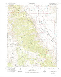
1962 Map of Mt. Barcroft
USGS Topo · Published 1975About this map
Fish Lake Valley serves as a primary point of human settlement in this high-altitude landscape along the Nevada California border. The map documents the mid-century agricultural and research presence in the White Mountains, featuring the White Mtn Research Sta Barcroft Laboratory and the Ancient Bristlecone Pine Area. Ranching operations such as the Circle L Ranch and McAfee Ranch occupy the lower basin, while the mountains are marked by a legacy of resource extraction at the Green Monster Mine and Evergreen Mine. A significant historical surveying artifact, the Von Schmidt Line Boundary, cuts through the terrain, reflecting the 19th-century efforts to define the state border. Small civic nodes like Dyer, with its Dyer Sch and Dyer PO, provide a glimpse into the isolated community life of Mono County during this era.
Find a feature on this map
67 named features on this map. Tap any name to fly to it.
Don’t see what you’re looking for? This feature index may not catch every label — zoom into the map to look around manually.
Map Details
Editions of this 1962 Mt. Barcroft Map
3 editions found

Other maps of this area

1898 · Silver Peak
USGS Topo · 1:125,000

1900 · Silver Peak
USGS Topo · 1:125,000

1908 · Lida
USGS Topo · 1:250,000

1913 · Bishop
USGS Topo · 1:125,000

1913 · Lida
USGS Topo · 1:250,000

1917 · White Mountain
USGS Topo · 1:125,000

1947 · Mariposa
USGS Topo · 1:250,000

1948 · Mariposa
USGS Topo · 1:250,000

1949 · Bishop
USGS Topo · 1:62,500

1951 · Bishop
USGS Topo · 1:62,500