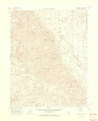
1962 Map of Mt. Barcroft
USGS Topo · Published 1975About this map
Fish Lake Valley straddles the California and Nevada border, where high-altitude research and ranching met in the mid-20th century. High peaks of the Inyo National Forest dominate the western terrain, featuring the White Mtn Research Sta Barcroft Laboratory (Univ of Calif) near Mt Barcroft. This remote environment is also home to the Ancient Bristlecone Pine Area, where the noted Patriarch Tree stands as a landmark of natural longevity.
Find a feature on this map
65 named features on this map. Tap any name to fly to it.
Don’t see what you’re looking for? This feature index may not catch every label — zoom into the map to look around manually.
Map Details
Editions of this 1962 Mt. Barcroft Map
3 editions found

Other maps of this area

1898 · Silver Peak
USGS Topo · 1:125,000

1900 · Silver Peak
USGS Topo · 1:125,000

1908 · Lida
USGS Topo · 1:250,000

1913 · Bishop
USGS Topo · 1:125,000

1913 · Lida
USGS Topo · 1:250,000

1917 · White Mountain
USGS Topo · 1:125,000

1947 · Mariposa
USGS Topo · 1:250,000

1948 · Mariposa
USGS Topo · 1:250,000

1949 · Bishop
USGS Topo · 1:62,500

1951 · Bishop
USGS Topo · 1:62,500