
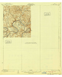
1932 Map of Mt. Bonnell
USGS Topo · Published 1932About this map
The Colorado River winds through the heart of the Texas Hill Country in this early 1930s survey, long before the creation of Lake Travis submerged much of the river's original path. The landscape is defined by its deep meanders and distinct landforms such as Hudson Bend, Arkansas Bend, and Horseshoe Bend. This map captures a pre-dam era where river crossings were still essential to local travel, evidenced by the numerous named crossings like Lohmann Ford, Stewart Ford, and Watson Ford.
Find a feature on this map
19 named features on this map. Tap any name to fly to it.
Don’t see what you’re looking for? This feature index may not catch every label — zoom into the map to look around manually.
Map Details
Editions of this 1932 Mt. Bonnell Map
2 editions found
Other maps of this area

1887 · Blanco
USGS Topo · 1:125,000

1887 · Burnet
USGS Topo · 1:125,000

1893 · Georgetown
USGS Topo · 1:125,000

1893 · Burnet
USGS Topo · 1:125,000

1894 · Blanco
USGS Topo · 1:125,000

1896 · Austin
USGS Topo · 1:125,000

1897 · Austin
USGS Topo · 1:125,000

1903 · Burnet
USGS Topo · 1:125,000

1909 · Burnet
USGS Topo · 1:125,000

1910 · Austin
USGS Topo · 1:125,000