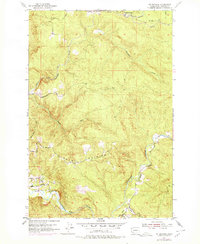
1953 Map of Mt. Brynion
USGS Topo · Published 1979About this map
Timber harvesting and river valley topography dominate this 1950s survey of the Mt Brynion area. The landscape is etched with the infrastructure of the mid-century lumber industry, most notably a complex network of Logging Railroad and Private Logging RR lines that wind through the upland ridges. At the northern edge of the map, a central Headquarters facility serves as a hub for these rail operations, while the southern portion of the sheet is defined by the winding course of the Coweman River. This river corridor includes functional markings such as a Gaging Sta and a Cable Crossing, reflecting the active management of the waterway. Steep terrain is drained by numerous tributaries, including Ostrander Creek and the South Fork Ostrander Creek, which carve deep valleys through the heavily contoured hillsides.
Find a feature on this map
20 named features on this map. Tap any name to fly to it.
Don’t see what you’re looking for? This feature index may not catch every label — zoom into the map to look around manually.
Map Details
Editions of this 1953 Mt. Brynion Map
4 editions found
Other maps of this area

1921 · Kalama
USGS Topo · 1:62,500

1941 · Olequa
USGS Topo · 1:62,500

1942 · Toutle
USGS Topo · 1:62,500

1943 · Pigeon Springs
USGS Topo · 1:62,500

1953 · Hoquiam
USGS Topo · 1:250,000

1953 · Toutle
USGS Topo · 1:62,500

1953 · Castle Rock
USGS Topo · 1:62,500

1953 · Mt. Brynion
USGS Topo · 1:24,000

1953 · Pigeon Springs
USGS Topo · 1:62,500

1953 · Rainier
USGS Topo · 1:24,000