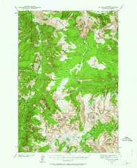
1941 Map of Mt Douglas
USGS Topo · Published 1962About this map
Mount Douglas and the high elevations of the Boulder Plateau dominate this high-altitude survey conducted during the early 1940s. The landscape is a complex network of glacial lakes and mountain drainages, including Emerald Lake, Mirror Lake, and the Rainbow Lakes. Human activity is concentrated around scattered mountain outposts and industrial sites, notably the Gish Mine located near the northern boundary.
Find a feature on this map
79 named features on this map. Tap any name to fly to it.
Don’t see what you’re looking for? This feature index may not catch every label — zoom into the map to look around manually.
Map Details
Editions of this 1941 Mt Douglas Map
4 editions found

Other maps of this area

1891 · Livingston
USGS Topo · 1:250,000

1891 · Big Timber
USGS Topo · 1:125,000

1893 · Livingston
USGS Topo · 1:250,000

1893 · Big Timber
USGS Topo · 1:125,000

1898 · Granite Mountain District
USGS Topo · 1:125,000

1932 · Nye No 2
USGS Topo · 1:48,000

1939 · Mt Wood
USGS Topo · 1:62,500

1940 · Mt. Cowen
USGS Topo · 1:62,500

1940 · Mt Wallace
USGS Topo · 1:62,500

1941 · Mt. Wood
USGS Topo · 1:62,500