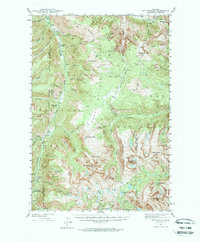
1941 Map of Mt Douglas
USGS Topo · Published 1972About this map
Clydehurst Ranch and Hells Canyon Ranch sit along the winding course of the Boulder River during the early 1940s, marking the edges of settlement before the terrain rises into the high peaks of the Absaroka Range. This survey, conducted by J. L. Lewis and J. J. Hayes, details the intersection of the Gallatin National Forest and Custer National Forest. The landscape is dominated by the massive Boulder Plateau and the prominent summit of Mt Douglas.
Find a feature on this map
74 named features on this map. Tap any name to fly to it.
Don’t see what you’re looking for? This feature index may not catch every label — zoom into the map to look around manually.
Map Details
Editions of this 1941 Mt Douglas Map
4 editions found

Other maps of this area

1891 · Livingston
USGS Topo · 1:250,000

1891 · Big Timber
USGS Topo · 1:125,000

1893 · Livingston
USGS Topo · 1:250,000

1893 · Big Timber
USGS Topo · 1:125,000

1898 · Granite Mountain District
USGS Topo · 1:125,000

1932 · Nye No 2
USGS Topo · 1:48,000

1939 · Mt Wood
USGS Topo · 1:62,500

1940 · Mt. Cowen
USGS Topo · 1:62,500

1940 · Mt Wallace
USGS Topo · 1:62,500

1941 · Mt. Wood
USGS Topo · 1:62,500