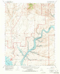
1953 Map of Mt. Ellsworth
USGS Topo · Published 1971About this map
Mt Ellsworth dominates the northern reaches of this landscape, anchoring the Henry Mountains as they descend into the Spring Desert. This 1953 survey, updated with 1970 revisions, documents a critical transition in the Utah canyonlands following the creation of the Glen Canyon National Recreation Area. The flooding of the Colorado River canyon is clearly visible, showing Lake Powell reaching into ancient drainages such as Stanton Canyon and Forgotten Canyon. On the western edge of the lake, the presence of the Landing Strip and Bullfrog Basin Campground reflects the area's mid-century shift toward recreation. Historically significant sites like Hoskinnini Mesa and Moki Tank remain as landmarks above the rising waters, while the eastern portion of the sheet is defined by the high plateaus of Ticaboo Mesa and Good Hope Mesa.
Find a feature on this map
38 named features on this map. Tap any name to fly to it.
Don’t see what you’re looking for? This feature index may not catch every label — zoom into the map to look around manually.
Map Details
Editions of this 1953 Mt. Ellsworth Map
4 editions found

Other maps of this area

1886 · Henry Mountains
USGS Topo · 1:250,000

1892 · Henry Mountains
USGS Topo · 1:250,000

1952 · Mt Pennell 1 SW
USGS Topo · 1:24,000

1952 · Mancos Mesa
USGS Topo · 1:62,500

1952 · Mt Hillers
USGS Topo · 1:62,500

1952 · Mt Pennell 1 SE
USGS Topo · 1:24,000

1952 · Hite
USGS Topo · 1:62,500

1953 · Mt Pennell
USGS Topo · 1:62,500

1953 · Mt Pennell 2 SE
USGS Topo · 1:24,000

1953 · Mt Pennell 4 NE
USGS Topo · 1:24,000