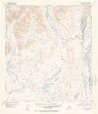
1952 Map of Mt. Hayes A-6
USGS Topo · Published 1953About this map
The Maclaren River corridor dominates this high-altitude Alaskan landscape, where a sprawling network of braided glacial streams and kettle ponds characterizes the valley floor. In the early 1950s, the only evidence of human infrastructure is the Sled Road that follows the West Fork before crossing the river toward the east. This route represents a vital winter transport corridor through the wilderness, connecting remote drainages such as Clearwater Creek and Coal Creek. The terrain is marked by significant topographical markers like VABM 5906 Little, providing a glimpse into the survey efforts of the mid-20th century. The intricate drainage patterns of Little Clearwater Creek and its many unnamed tributaries illustrate the complex hydrology of this subarctic environment prior to modern development.
Find a feature on this map
9 named features on this map. Tap any name to fly to it.
Don’t see what you’re looking for? This feature index may not catch every label — zoom into the map to look around manually.
Map Details
Editions of this 1952 Mt. Hayes A-6 Map
3 editions found

Other maps of this area

1949 · Healy A-1
USGS Topo · 1:63,360

1949 · Mount Hayes A-5
USGS Topo · 1:63,360

1950 · Talkeetna Mountains
USGS Topo · 1:250,000

1950 · Mount Hayes
USGS Topo · 1:250,000

1950 · Healy B-1
USGS Topo · 1:63,360

1950 · Mount Hayes A-6
USGS Topo · 1:63,360

1951 · Healy
USGS Topo · 1:250,000

1951 · Gulkana
USGS Topo · 1:250,000

1951 · Mount Hayes
USGS Topo · 1:250,000

1951 · Gulkana D-6
USGS Topo · 1:63,360