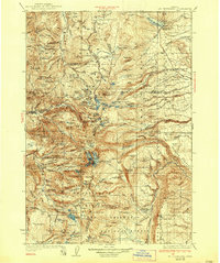
1930 Map of Mt. Jefferson
USGS Topo · Published 1938About this map
Mt Jefferson dominates this high-altitude landscape, where the boundaries of the Warm Springs Indian Reservation, the Mount Hood National Forest, and the Deschutes National Forest converge. Surveyed in 1927, the map captures a period of early conservation and managed wilderness, centered on the Mt Jefferson Primitive Area. The drainage patterns are clearly defined, with the Warm Springs River and Shitike Creek flowing eastward across the reservation, while the Whitewater River and Breitenbush River head westward through the national forest lands.
Find a feature on this map
136 named features on this map. Tap any name to fly to it.
Don’t see what you’re looking for? This feature index may not catch every label — zoom into the map to look around manually.
Map Details
Editions of this 1930 Mt. Jefferson Map
3 editions found
Other maps of this area

1916 · Estacada
USGS Topo · 1:125,000

1924 · Mount Hood
USGS Topo · 1:125,000

1926 · Bend
USGS Topo · 1:125,000

1927 · Mount Hood
USGS Topo · 1:125,000

1927 · Mt. Jefferson
USGS Topo · 1:125,000

1928 · Madras
USGS Topo · 1:125,000

1929 · Mill City
USGS Topo · 1:125,000

1929 · Bend
USGS Topo · 1:125,000

1929 · Three Sisters
USGS Topo · 1:125,000

1930 · Mt. Jefferson
USGS Topo · 1:125,000