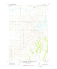
1951 Map of Mt. Katmai A-5
USGS Topo · Published 1975About this map
Katmai National Monument dominates this mid-century topographic study, which captures the glaciated and volcanic landscape of southwestern Alaska as it was surveyed in the early 1950s. The northern reaches are defined by the winding course of Angle Creek, while the southern portion transition into the drainage basin of the Kejulik River. High-elevation landmarks like Mt Martin and the treacherous Crevasses near the mountain slopes highlight the active glacial activity characteristic of this volcanic arc.
Find a feature on this map
10 named features on this map. Tap any name to fly to it.
Don’t see what you’re looking for? This feature index may not catch every label — zoom into the map to look around manually.
Map Details
Editions of this 1951 Mt. Katmai A-5 Map
3 editions found

Other maps of this area

1948 · Mt Katmai
USGS Topo · 1:250,000

1951 · Mt Katmai
USGS Topo · 1:250,000

1951 · Karluk
USGS Topo · 1:250,000

1951 · Mount Katmai A-6
USGS Topo · 1:63,360

1951 · Mount Katmai B-4
USGS Topo · 1:63,360

1951 · Mount Katmai B-6
USGS Topo · 1:63,360

1951 · Karluk D-6
USGS Topo · 1:63,360

1951 · Karluk D-4
USGS Topo · 1:63,360

1951 · Mount Katmai A-4
USGS Topo · 1:63,360

1951 · Karluk D-5
USGS Topo · 1:63,360