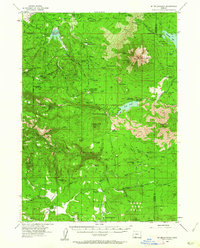
1955 Map of Mt. Mc Loughlin
USGS Topo · Published 1962About this map
Mt Mc Loughlin dominates the northeast quadrant of this mid-century survey, surrounded by the high-elevation terrain of the Rogue River National Forest. The landscape is a network of water and timber infrastructure, including the Willow Creek Reservoir and numerous forest camps such as Calamity Forest Camp and Willow Prairie Forest Camp. For local historians and genealogists, the map preserves the locations of early 20th-century outposts like Swede Cabin and the Deadwood townsite.
Find a feature on this map
97 named features on this map. Tap any name to fly to it.
Don’t see what you’re looking for? This feature index may not catch every label — zoom into the map to look around manually.
Map Details
Editions of this 1955 Mt. Mc Loughlin Map
3 editions found

Other maps of this area

1891 · Ashland
USGS Topo · 1:250,000

1893 · Ashland
USGS Topo · 1:250,000

1897 · Ashland
USGS Topo · 1:250,000

1938 · Medford
USGS Topo · 1:125,000

1954 · Butte Falls
USGS Topo · 1:62,500

1954 · Lakecreek
USGS Topo · 1:62,500

1954 · Ashland
USGS Topo · 1:62,500

1955 · Lake O' Woods
USGS Topo · 1:62,500

1955 · Surveyor Mtn
USGS Topo · 1:62,500

1955 · Rustler Peak
USGS Topo · 1:62,500