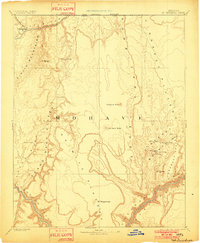
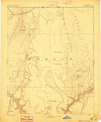
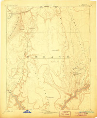
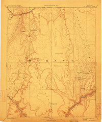
1892 Map of Mt. Trumbull
USGS Topo · Published 1901About this map
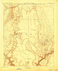
The Colorado River and Virgin River define the lower and upper reaches of this northwestern Arizona landscape as it was documented by the Powell Survey in the late nineteenth century. This reconnaissance highlights a region dominated by massive geologic formations, where the Shiwits Plateau and Uinkaret Plateau are separated by the striking Hurricane Ledge. Sparse but critical water sources are carefully noted, including Blackrocks Spring, Cane Spring, and the high-elevation Trumbull Spring. Settlement is minimal in this era, represented by the cluster at Beaverdam and the remote Pierce Ferry crossing on the Colorado. The map traces the prominent peaks of the Uinkaret Volcanic Field, such as Mt Trumbull, Mt Logan, and Mt Emma, which provided essential landmarks for early explorers and surveyors navigating the Toroweap Valley and the surrounding high desert wilderness.
Find a feature on this map
28 named features on this map. Tap any name to fly to it.
Don’t see what you’re looking for? This feature index may not catch every label — zoom into the map to look around manually.
Map Details
Editions of this 1892 Mt. Trumbull Map
6 editions found

Other maps of this area

1885 · St. George
USGS Topo · 1:250,000

1885 · Pioche
USGS Topo · 1:250,000

1886 · Diamond Creek
USGS Topo · 1:250,000

1886 · Camp Mohave
USGS Topo · 1:250,000

1886 · Kanab
USGS Topo · 1:250,000

1886 · Saint Thomas
USGS Topo · 1:250,000

1886 · Mt. Trumbull
USGS Topo · 1:250,000

1886 · Chino
USGS Topo · 1:250,000

1886 · Pioche
USGS Topo · 1:250,000

1886 · Kaibab
USGS Topo · 1:250,000