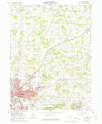
1961 Map of Mt Vernon
USGS Topo · Published 1975About this map
The Kokosing River flows through this Knox County landscape, anchoring the bustling commercial and civic center of Mt Vernon. By the early 1960s, the city displays a dense network of neighborhoods, schools, and institutional landmarks, including the sprawling Mt Vernon State Hospital complex and the Knox-Vernon Speedway. The map captures a moment when the Baltimore and Ohio and Penn Central railroads remained vital corridors for local industry and transport.
Find a feature on this map
79 named features on this map. Tap any name to fly to it.
Don’t see what you’re looking for? This feature index may not catch every label — zoom into the map to look around manually.
Map Details
Editions of this 1961 Mt Vernon Map
4 editions found
Other maps of this area

1912 · Gambier
USGS Topo · 1:62,500

1912 · Perrysville
USGS Topo · 1:62,500

1914 · Gambier
USGS Topo · 1:62,500

1915 · Perrysville
USGS Topo · 1:62,500

1915 · Shauck
USGS Topo · 1:62,500

1915 · Fredericktown
USGS Topo · 1:62,500

1943 · Shauck
USGS Topo · 1:62,500

1943 · Gambier
USGS Topo · 1:62,500

1943 · Fredericktown
USGS Topo · 1:62,500

1944 · Perrysville
USGS Topo · 1:62,500