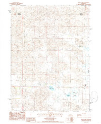
1986 Map of Mudd Lake
USGS Topo · Published 1986About this map
Mudd Lake and the surrounding Logan County landscape are defined by a complex network of closed basins and seasonal wetlands characteristic of the Nebraska Sandhills. This 1980s survey captures a rural environment focused on livestock production, as evidenced by the presence of Feed Lots and the isolated Rogers Ranch to the north. The undulating terrain transition between the open Flats and the named area of Wild Horse suggests a topography of high dunes and low-lying meadow pockets. Drainage is minimal across this sandy expanse, with Wild Horse Creek and Philpott Lake representing the few significant water features in a region where surface water often depends on the level of the shallow Ogallala Aquifer. The boundary between Thomas and Logan counties cuts across the northern reaches of the sheet, marking a quiet divide in this sparsely populated cattle country.
Find a feature on this map
8 named features on this map. Tap any name to fly to it.
Don’t see what you’re looking for? This feature index may not catch every label — zoom into the map to look around manually.
Map Details
Editions of this 1986 Mudd Lake Map
This is the sole edition of this map. No revisions or reprints were ever made.
Other maps of this area

1948 · Thedford
USGS Topo · 1:62,500

1948 · Halsey
USGS Topo · 1:62,500

1949 · Cody Lake
USGS Topo · 1:62,500

1950 · Thedford
USGS Topo · 1:62,500

1950 · Halsey
USGS Topo · 1:62,500

1951 · Cody Lake
USGS Topo · 1:62,500

1951 · Hoagland
USGS Topo · 1:62,500

1954 · North Platte
USGS Topo · 1:250,000

1956 · North Platte
USGS Topo · 1:250,000

1957 · North Platte
USGS Topo · 1:250,000