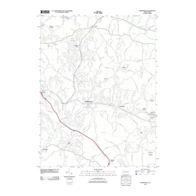
2010 Map of Murrysville
USGS Topo · Published 2010About this map
Murrysville serves as the central hub of this eastern Pennsylvania landscape, where the legacy of coal mining and suburban development meet. The northern reaches are characterized by industrial markers such as the Plum Creek Mine and the Renton Slurry Pond Three Dam, while numerous residential clusters like Holiday Park and Level Green illustrate the area's growth. The topography is defined by the winding paths of Turtle Creek and Lyons Run, which once dictated the placement of early settlements and transport routes.
Find a feature on this map
108 named features on this map. Tap any name to fly to it.
Don’t see what you’re looking for? This feature index may not catch every label — zoom into the map to look around manually.
Map Details
Editions of this 2010 Murrysville Map
This is the sole edition of this map. No revisions or reprints were ever made.
Other maps of this area

1904 · Mc Keesport
USGS Topo · 1:62,500

1904 · Greensburg
USGS Topo · 1:62,500

1906 · Greensburg
USGS Topo · 1:62,500

1907 · Pittsburg
USGS Topo · 1:62,500

1907 · Freeport
USGS Topo · 1:62,500

1908 · New Kensington
USGS Topo · 1:62,500

1909 · Freeport
USGS Topo · 1:62,500

1910 · New Kensington
USGS Topo · 1:62,500

1953 · Pittsburgh
USGS Topo · 1:250,000
1953 · Mc Keesport
USGS Topo · 1:24,000