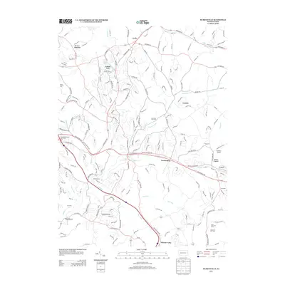
2013 Map of Murrysville
USGS Topo · Published 2013About this map
Newlonsburg and the surrounding Westmoreland and Allegheny County landscapes are captured here during a period of established residential development and suburban recreation. The terrain is defined by a dense network of watercourses, including Turtle Creek, Lyons Run, and Abers Creek, which wind through the varied topography of Round Top and Kemerer Hollow. This 2013 survey illustrates the modern footprint of settlements like Export and West Export, alongside older junctions such as Renton Junction. Recreational spaces are prominent across the quadrangle, notably the Boyce Park Ski Area in the west and several golf courses, including Murrysville Golf Course and Manor Valley Golf Course. The map also records smaller communities and residential enclaves such as Holiday Park, Sardis, and Level Green, providing a detailed look at the infrastructure connecting these historic and modern settlements.
Find a feature on this map
195 named features on this map. Tap any name to fly to it.
Don’t see what you’re looking for? This feature index may not catch every label — zoom into the map to look around manually.
Map Details
Editions of this 2013 Murrysville Map
This is the sole edition of this map. No revisions or reprints were ever made.
Other maps of this area

1904 · Mc Keesport
USGS Topo · 1:62,500

1904 · Greensburg
USGS Topo · 1:62,500

1906 · Greensburg
USGS Topo · 1:62,500

1907 · Pittsburg
USGS Topo · 1:62,500

1907 · Freeport
USGS Topo · 1:62,500

1908 · New Kensington
USGS Topo · 1:62,500

1909 · Freeport
USGS Topo · 1:62,500

1910 · New Kensington
USGS Topo · 1:62,500

1953 · Pittsburgh
USGS Topo · 1:250,000
1953 · Mc Keesport
USGS Topo · 1:24,000