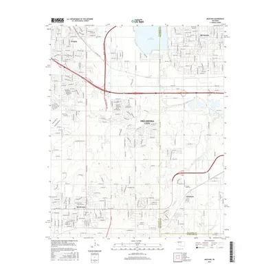
2016 Map of Mustang
USGS Topo · Published 2016About this map
Mustang and the nearby community of Wheatland anchor this 2016 survey, which documents the suburban expansion south of Lake Overholser. The landscape shows a mix of established residential grids and newer developments bound by the John Kilpatrick Turnpike. Traces of the area's older rural character remain visible in the placement of the Mustang Cem and Pleasant Valley Cem, alongside small water bodies like Mulvey Pond. The North Canadian River flows across the northeastern corner, marking the boundary near Bethany. Local drainages such as Mustang Cr and Campbell Cr weave between neighborhoods, while specific routes like Oil Lease Rd hint at the region's industrial and energy history. The map captures the meeting point of Canadian, Oklahoma, and Cleveland counties, reflecting a transition from open prairie to a modern urban corridor.
Find a feature on this map
25 named features on this map. Tap any name to fly to it.
Don’t see what you’re looking for? This feature index may not catch every label — zoom into the map to look around manually.
Map Details
Editions of this 2016 Mustang Map
This is the sole edition of this map. No revisions or reprints were ever made.
Other maps of this area

1892 · Kingfisher
USGS Topo · 1:125,000

1893 · Oklahoma City
USGS Topo · 1:62,500

1893 · Minco
USGS Topo · 1:62,500

1895 · Kingfisher
USGS Topo · 1:125,000

1904 · Chickasha
USGS Topo · 1:125,000

1951 · Britton
USGS Topo · 1:24,000

1954 · Oklahoma City
USGS Topo · 1:250,000

1956 · Oklahoma City
USGS Topo · 1:24,000

1956 · Oklahoma City
USGS Topo · 1:62,500

1956 · Oklahoma City SE
USGS Topo · 1:24,000