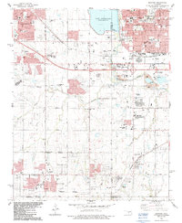
1986 Map of Mustang
USGS Topo · Published 1987About this map
The North Canadian River winds through this mid-1980s landscape, serving as a corridor for industrial and suburban growth between Yukon, Bethany, and Mustang. The map captures the area during a period of significant expansion, where extensive Oil and Gas Fields and sandpits sit adjacent to burgeoning residential developments and community institutions like Czech Hall and the Canadian Valley Chapel. To the north, Lake Overholser dominates the terrain, with its spillway and surrounding recreation areas such as Tropicana Pk and Brown Park.
Find a feature on this map
60 named features on this map. Tap any name to fly to it.
Don’t see what you’re looking for? This feature index may not catch every label — zoom into the map to look around manually.
Map Details
Editions of this 1986 Mustang Map
This is the sole edition of this map. No revisions or reprints were ever made.
Other maps of this area

1892 · Kingfisher
USGS Topo · 1:125,000

1893 · Oklahoma City
USGS Topo · 1:62,500

1893 · Minco
USGS Topo · 1:62,500

1895 · Kingfisher
USGS Topo · 1:125,000

1904 · Chickasha
USGS Topo · 1:125,000

1951 · Britton
USGS Topo · 1:24,000

1954 · Oklahoma City
USGS Topo · 1:250,000

1956 · Oklahoma City
USGS Topo · 1:24,000

1956 · Oklahoma City
USGS Topo · 1:62,500

1956 · Oklahoma City SE
USGS Topo · 1:24,000