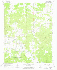
1962 Map of Myron
USGS Topo · Published 1976About this map
The Strawberry River and its major tributary, the Piney Fork Strawberry River, carve through the Ozark landscape of northern Arkansas in this early 1960s survey. The small settlement of Myron serves as a central point for the surrounding rural area, which is dotted with small family and community burial grounds such as Bates Cem, Godwin Cem, and Hills Chapel Cem. The map reveals a highly localized geography of place-names, where small waterways like Mc Junkins Branch and Hinson Branch drain the ridges between Davidson Hill and Baker Hill. This era captures the region before extensive modern development, showing the original network of unimproved dirt roads and light-duty paths that connected isolated homesteads and local landmarks across the Izard and Sharp County line.
Find a feature on this map
31 named features on this map. Tap any name to fly to it.
Don’t see what you’re looking for? This feature index may not catch every label — zoom into the map to look around manually.
Map Details
Editions of this 1962 Myron Map
3 editions found

Other maps of this area

1950 · Salem
USGS Topo · 1:62,500

1951 · Salem
USGS Topo · 1:62,500

1951 · Melbourne
USGS Topo · 1:62,500

1957 · Poplar Bluff
USGS Topo · 1:250,000

1959 · Poplar Bluff
USGS Topo · 1:250,000

1960 · Poplar Bluff
USGS Topo · 1:250,000
1961 · Evening Shade
USGS Topo · 1:24,000

1962 · Stuart
USGS Topo · 1:24,000

1962 · Ash Flat
USGS Topo · 1:24,000
1962 · Sidney
USGS Topo · 1:24,000