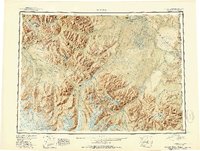
1951 Map of Nabesna
USGS Topo · Published 1951About this map
The Tetlin Indian Reservation occupies the center of this reconnaissance study, where the high peaks of the Mentasta Mountains and Nutzotin Mountains meet the vast drainage of the Nabesna River. In the early 1950s, this region was a critical junction of mountain passes and nascent aviation infrastructure, featuring remote strips like Reeve Field and Northway Landing Field. The landscape is dominated by the massive Nabesna Glacier flowing from the Wrangell Mountains, while early settlements and mining sites such as Nabesna and Gold Hill are documented near the headwaters. Evidence of early land management and transportation is visible in the corridor of the Alaska Highway and the boundary line between the Third Judicial Division and Fourth Judicial Division. This sheet captures a transitional era when traditional native settlements like Mentasta Village and Nabesna Village coexisted with the expanding reach of federal surveys and the post-war aviation network.
Find a feature on this map
101 named features on this map. Tap any name to fly to it.
Don’t see what you’re looking for? This feature index may not catch every label — zoom into the map to look around manually.
Map Details
Editions of this 1951 Nabesna Map
3 editions found

Other maps of this area

1948 · Tanacross A-6
USGS Topo · 1:63,360

1948 · Tanacross A-3
USGS Topo · 1:63,360

1948 · Tanacross A-4
USGS Topo · 1:63,360

1948 · Nabesna C-6
USGS Topo · 1:63,360

1948 · Nabesna D-5
USGS Topo · 1:63,360

1948 · Tanacross A-5
USGS Topo · 1:63,360

1949 · Tanacross
USGS Topo · 1:250,000

1949 · Nabesna D-6
USGS Topo · 1:63,360

1949 · Tanacross A-5
USGS Topo · 1:63,360

1949 · Gulkana C-1
USGS Topo · 1:63,360