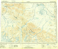
1951 Map of Nabesna
USGS Topo · Published 1951About this map
The Nabesna Glacier feeds the massive river systems that define this interior Alaskan landscape at the junction of the Wrangell Mountains and the Nutzotin Mountains. This 1951 provisional compilation documents the region as the modern road network was taking shape, most notably with the Alaska Highway cutting through the northeast and the Slana-Tok Highway crossing Mentasta Pass. Indigenous life and history are centered around the Tetlin Indian Reservation, Mentasta Village, and Nabesna Village. The map serves as a detailed record of high-altitude aviation and early transport, marking remote strips like Northway Landing Field and Reeve Field alongside ancient trails. Glacial features such as the Carl Glacier and high peaks like Mt Jarvis and Tanada Peak dominate the southern half of the sheet, providing a precise look at the drainage patterns of the Nabesna River and the Tanana River.
Find a feature on this map
123 named features on this map. Tap any name to fly to it.
Don’t see what you’re looking for? This feature index may not catch every label — zoom into the map to look around manually.
Map Details
Editions of this 1951 Nabesna Map
3 editions found

Other maps of this area

1948 · Tanacross A-6
USGS Topo · 1:63,360

1948 · Tanacross A-3
USGS Topo · 1:63,360

1948 · Tanacross A-4
USGS Topo · 1:63,360

1948 · Nabesna C-6
USGS Topo · 1:63,360

1948 · Nabesna D-5
USGS Topo · 1:63,360

1948 · Tanacross A-5
USGS Topo · 1:63,360

1949 · Tanacross
USGS Topo · 1:250,000

1949 · Nabesna D-6
USGS Topo · 1:63,360

1949 · Tanacross A-5
USGS Topo · 1:63,360

1949 · Gulkana C-1
USGS Topo · 1:63,360