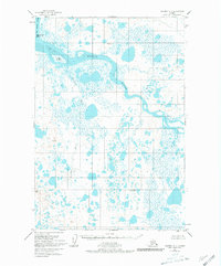
1951 Map of Naknek A-4
USGS Topo · Published 1981About this map
The Egegik River and King Salmon River converge in this low-lying coastal landscape, which was mapped via aerial photography in the early 1950s. This specific region of Alaska is defined by its intricate hydrology, where land and water merge through a complex network of unnamed ponds and the meandering course of the Swampy River. Near the shoreline, King Salmon Island and Egg Island sit within a significant Tidal Flat, marking the transition to the sea. A lone Cabin in the southern interior provides one of the few indicators of human presence, likely serving as a seasonal shelter or outpost. This survey reflects the remote character of the area prior to later decades of development, documenting a wilderness defined primarily by its seasonal saturation and untouched river systems.
Find a feature on this map
7 named features on this map. Tap any name to fly to it.
Don’t see what you’re looking for? This feature index may not catch every label — zoom into the map to look around manually.
Map Details
Editions of this 1951 Naknek A-4 Map
3 editions found
Other maps of this area

1943 · Ugashik
USGS Topo · 1:250,000

1948 · Ugashik
USGS Topo · 1:250,000

1949 · Ugashik
USGS Topo · 1:250,000

1951 · Ugashik D-5 and D-6
USGS Topo · 1:63,360

1951 · Ugashik D-3
USGS Topo · 1:63,360

1951 · Ugashik D-4
USGS Topo · 1:63,360

1951 · Naknek A-5
USGS Topo · 1:63,360

1951 · Naknek A-4
USGS Topo · 1:63,360

1951 · Naknek A-3
USGS Topo · 1:63,360

1952 · Naknek
USGS Topo · 1:250,000