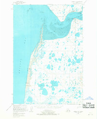
1951 Map of Naknek A-5
USGS Topo · Published 1968About this map
Egegik sits at the mouth of Egegik Bay, serving as a critical point of maritime and industrial activity on the Bristol Bay coast during the early 1950s. The landscape is dominated by extensive Tidal Flats and winding channels that define the entrance to the bay. A prominent Cannery and a designated Landing Area underscore the region's reliance on the seasonal salmon fishery and air transport for connectivity. Along the southern shore, a series of survey markers including VABM 181 Egegik and VABM 26 Egegik S Base trace the coastal elevation. The northern entrance is marked by Red Bluff Light and Bishop Creek, while to the west, the open waters of Bristol Bay meet the distinctive landforms of Goose Pt and South Spit. This survey captures the specialized infrastructure of the Alaskan fishing industry before modern expansion.
Find a feature on this map
17 named features on this map. Tap any name to fly to it.
Don’t see what you’re looking for? This feature index may not catch every label — zoom into the map to look around manually.
Map Details
Editions of this 1951 Naknek A-5 Map
3 editions found
Other maps of this area

1943 · Ugashik
USGS Topo · 1:250,000

1948 · Ugashik
USGS Topo · 1:250,000

1949 · Ugashik
USGS Topo · 1:250,000

1951 · Ugashik D-5 and D-6
USGS Topo · 1:63,360

1951 · Ugashik D-4
USGS Topo · 1:63,360

1951 · Naknek A-5
USGS Topo · 1:63,360

1951 · Naknek A-4
USGS Topo · 1:63,360

1952 · Naknek
USGS Topo · 1:250,000

1952 · Naknek B-4
USGS Topo · 1:63,360

1952 · Naknek B-5
USGS Topo · 1:63,360