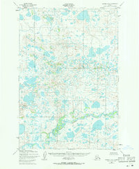
1952 Map of Naknek B-4
USGS Topo · Published 1971About this map
King River and the Salmon River dominate the southern portion of this 1952 topographic study, where they converge amidst an intricate network of wetlands and small lakes. In the north, Big Creek winds through a landscape defined by thousands of nameless ponds and kettle lakes, characteristic of the Bristol Bay region's glacial legacy. The map, based on 1951 aerial photography, documents a period when this vast interior remained entirely undeveloped, as indicated by the note stating no roads or trails existed in the area at the time of the survey. For researchers, this document provides a precise baseline of the hydrology and natural drainage patterns of the King River basin before any modern human impacts reached this corner of the Alaska Peninsula.
Find a feature on this map
8 named features on this map. Tap any name to fly to it.
Don’t see what you’re looking for? This feature index may not catch every label — zoom into the map to look around manually.
Map Details
Editions of this 1952 Naknek B-4 Map
3 editions found
Other maps of this area

1951 · Naknek A-5
USGS Topo · 1:63,360

1951 · Naknek A-4
USGS Topo · 1:63,360

1951 · Naknek A-3
USGS Topo · 1:63,360

1952 · Naknek
USGS Topo · 1:250,000

1952 · Naknek B-3
USGS Topo · 1:63,360

1952 · Naknek C-5
USGS Topo · 1:63,360

1952 · Naknek B-4
USGS Topo · 1:63,360

1952 · Naknek B-5
USGS Topo · 1:63,360

1952 · Naknek C-3
USGS Topo · 1:63,360

1952 · Naknek C-4
USGS Topo · 1:63,360