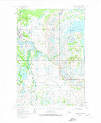
1952 Map of Naknek C-2
USGS Topo · Published 1974About this map
The Naknek River serves as the central artery of this early 1950s landscape, winding through a complex network of marshes and smaller tributaries toward Bristol Bay. This era shows King Salmon in a period of strategic importance, centered around the King Salmon Airport and an extensive Military Reservation complete with Radio Towers. The eastern portion of the map transitions into the protected wilderness of Katmai National Monument, where the shores of Naknek Lake are dotted with a Recreation Camp and Cabins. Grounded in data from 1951 aerial photography, the sheet documents a specific moment when wilderness and defense infrastructure coexisted. Transport is characterized by natural waterways and a long Winter Trail cutting through the southern terrain, while coastal features like The Lower Lagoon and Grassy Pt define the estuarine environment.
Find a feature on this map
18 named features on this map. Tap any name to fly to it.
Don’t see what you’re looking for? This feature index may not catch every label — zoom into the map to look around manually.
Map Details
Editions of this 1952 Naknek C-2 Map
2 editions found
Other maps of this area

1951 · Naknek D-1
USGS Topo · 1:63,360

1951 · Naknek B-1
USGS Topo · 1:63,360

1951 · Naknek C-1
USGS Topo · 1:63,360

1952 · Naknek
USGS Topo · 1:250,000

1952 · Naknek D-2
USGS Topo · 1:63,360

1952 · Naknek B-3
USGS Topo · 1:63,360

1952 · Naknek B-2
USGS Topo · 1:63,360

1952 · Naknek C-2
USGS Topo · 1:63,360

1952 · Naknek C-3
USGS Topo · 1:63,360

1952 · Naknek D-3
USGS Topo · 1:63,360