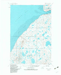
1952 Map of Naknek C-4
USGS Topo · Published 1983About this map
Naknek and South Naknek anchor the mouth of the Naknek River on this 1952 survey, which illustrates the maritime and aviation infrastructure vital to the Bristol Bay fishing industry. The map documents several Cannery operations and a Seaplane Base near Cape Suwarof, highlighting the remote logistical network of the era. To the southwest, the landscape is defined by the massive expanse of Big Flat and the elevations of Johnson Hill, where Johnson Hill Creek drains into the bay.
Find a feature on this map
15 named features on this map. Tap any name to fly to it.
Don’t see what you’re looking for? This feature index may not catch every label — zoom into the map to look around manually.
Map Details
Editions of this 1952 Naknek C-4 Map
2 editions found
Other maps of this area

1952 · Naknek
USGS Topo · 1:250,000

1952 · Naknek B-3
USGS Topo · 1:63,360

1952 · Naknek C-5
USGS Topo · 1:63,360

1952 · Naknek B-4
USGS Topo · 1:63,360

1952 · Naknek B-5
USGS Topo · 1:63,360

1952 · Naknek C-3
USGS Topo · 1:63,360

1952 · Naknek D-5
USGS Topo · 1:63,360

1952 · Naknek D-3
USGS Topo · 1:63,360

1952 · Naknek D-4
USGS Topo · 1:63,360

1952 · Naknek C-4
USGS Topo · 1:63,360