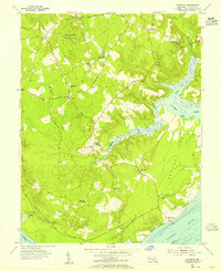
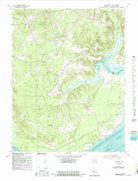
1954 Map of Nanjemoy
USGS Topo · Published 1955About this map
The Doncaster State Forest dominates the northern reaches of this coastal landscape, where the tidal fingers of Nanjemoy Creek and the Potomac River define the local geography. In the mid-1950s, the area maintained a rural, decentralized settlement pattern centered on community landmarks like St Ignatius Ch, Durham Ch, and Emory Chapel. The road network connects small crossroads such as Ironsides and Grayton, while the southern shore at Riverside and Maryland Point reflects the deep connection to the water. Local education is anchored by scattered schoolhouses including Nanjemoy Sch and Mt Hope Sch, documenting a way of life before significant modernization changed the character of western Charles County. The map captures the intricate shoreline of Barn Cove and the marshy transition at Thorne Gut Marsh, illustrating the complex drainage systems of the Potomac R watershed.
Find a feature on this map
27 named features on this map. Tap any name to fly to it.
Don’t see what you’re looking for? This feature index may not catch every label — zoom into the map to look around manually.
Map Details
Editions of this 1954 Nanjemoy Map
5 editions found
Other maps of this area

1889 · Fredericksburg
USGS Topo · 1:125,000

1890 · Mt. Vernon
USGS Topo · 1:125,000

1891 · Mt. Vernon
USGS Topo · 1:125,000

1892 · Fredericksburg
USGS Topo · 1:125,000

1894 · Fredericksburg
USGS Topo · 1:125,000

1894 · Mt. Vernon
USGS Topo · 1:125,000

1897 · Mt. Vernon
USGS Topo · 1:125,000

1913 · Indian Head
USGS Topo · 1:62,500
1913 · Nanjemoy
USGS Topo · 1:62,500

1923 · Indian Head
USGS Topo · 1:48,000